Stanford Humanities Center
From visualizations of complex information and interactive teaching platforms to digitization projects and textual analysis, humanities scholars across campus are harnessing the power of digital tools to push the boundaries of their research. Likewise, the unique properties of humanities scholarship are pushing the boundaries of digital tools.
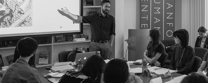
In this panel discussion, Stanford scholars and technical experts will talk about their work in the digital humanities. The conversation, which will be streamed live, will be moderated by Stanford Humanities Center Director Caroline Winterer and Zephyr Frank, Director of Stanford's Center for Spatial and Textual Analysis (CESTA.)
Click here to see the live webcast and videos profiling some of the digital humanities projects that will be featured on May 5.
ABOUT THE PARTICIPANTS
Caroline Winterer is the director of the Stanford Humanities Center and a researcher with Mapping the Republic of Letters, a collaborative project at Stanford to digitally map some of the major European and American correspondence networks and libraries of the early modern scholarly world. Winterer is Anthony P. Meier Family Professor in the Humanities, as well as Professor of History and (by courtesy) Classics at Stanford. She specializes in the intellectual and cultural history of eighteenth- and nineteenth-century America in its transatlantic contexts.
Zephyr Frank is the founding director of the Center for Spatial and Textual Analysis (CESTA) at Stanford. He is also the principal investigator in Terrain of History, an international collaborative project to digitally map nineteenth-century Rio de Janeiro in order to reconstruct and analyze the social, cultural, and economic spaces of the city. Terrain of History is affiliated with the Spatial History Project at CESTA. Frank is an Associate Professor of History at Stanford and director of the Program on Urban Studies, specializing in Brazilian social and cultural history and the study of wealth and inequality.
Elaine Treharne is principal investigator of Global Currents: Cultures of Literary Networks, 1050-1900, an inter-institutional project for the cross-cultural study of literary networks in a global context through the integration of image-processing with social network analysis. Treharne is the Roberta Bowman Denning Professor of Humanities and Professor of English and (by courtesy) German Studies, as well as the director of Text Technologies at Stanford. The medievalist scholar has published extensively on the material qualities and functions of Early British manuscripts and how studying these texts helps us understand the past and make connections with the present.
Paula Findlen is co-founder of Mapping the Republic of Letters, a collaborative project at Stanford to digitally map some of the major European and American correspondence networks and libraries of the early modern scholarly world. Findlen is chair of the Department of History, Ubaldo Pierotti Professor of Italian History, as well as director of the Patrick Suppes Center for the History and Philosophy of Science and Technology at Stanford. Her work centers on the early history of science and medicine.
Karl Grossner’s work as a geographer and digital humanities research developer at Stanford includes his role as co-developer of ORBIS, an interactive geospatial network model of the Roman world that reconstructs the duration and financial cost of travel in antiquity. Grossner is also a research developer in Çatalhöyük Living Archive, an experimental web application in its pilot phase representing data from a Neolithic settlement in present-day Turkey. He received a Ph.D. in Geography at University of California, Santa Barbara in 2010, with research interests are in the representation of historical knowledge in computational models of place.
Brian Johnsrud is co-director and project manager of Lacuna Stories, an interactive online annotation platform where people can research and discuss significant historical events like 9/11 using a wide array of sources and media. Johnsrud is currently completing a Ph.D. in Modern Thought and Literature at Stanford, specializing in U.S. and Middle Eastern cultural relations. He has also received masters degrees in library and media studies (Montana State University), medieval literature (Oxford), and cultural anthropology (Oxford).
Jason Heppler’s interest in applying digital tools to historical research has led him to work as a researcher in Geography of the Post. Part of the Spatial History Project at Stanford’s CESTA, the project analyzes the development of the American West through digital mapping of 19th-century U.S. Post Office locations. Heppler is the Academic Technology Specialist in the Department of History at Stanford and worked as a project manager for the William F. Cody Archive at the Center for Digital Research in the Humanities. His digital projects include Framing Red Power: The American Indian Movement, the Trail of Broken Treaties, and the Politics of Media and contributions to the Digital History Project, a clearinghouse for information about digital history. Heppler is completing a Ph.D. in History at the University of Nebraska-Lincoln, where his research focuses on the American West and digital history.
A FEW OF THE PROJECTS THAT WILL BE DISCUSSED
ORBIS: an interactive geospatial network model of the Roman world that reconstructs the duration and financial cost of travel in antiquity
Mapping the Republic of Letters: a collaborative project to digitally map some of the major European and American correspondence networks and libraries of the early modern scholarly world
Çatalhöyük Living Archive: an experimental web application representing data from decades of excavation and analysis at a Neolithic settlement in present-day Turkey
Lacuna Stories: an interactive online annotation platform where people can research and discuss significant historical events like 9/11 using a wide array of sources and media
Geography of the Post: a project that analyzes the development of the American West through digital mapping of 19th-century U.S. Post Office locations
Text Technologies: a project that explores the history of the book and evolving text technologies, analyzing manuscript and print forms alongside today’s digital environment
Enchanting the Desert: a digital, interactive platform that uses photographic georeferencing to allow viewers to explore a collection of Henry Peabody’s landscape photographs of the Grand Canyon
Mapping Galileo: a project that uses the surviving correspondence of mathematician and astronomer Galileo Galilei to map his social and intellectual networks

When
Share